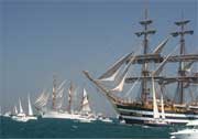
PalCom at Tall Ships' Race 2007
The 5th to 8th of July PalCom was perceptible to the eye in Aarhus in a way different from other dissemination activities.
In collaboration with police, fire brigade and hospital staff the Major Incidents Overview prototype was used on site and in the Commandstation at the harbour during the Tall Ships' Race 2007 event.
- Gallery: Follow link to see more pictures
- Broadcast: Follow link to see report from PalCom's participation
Between 70 and 100 vessels from 20 countries or more, crewed by approx. 4,000 young people from more than 30 countries worldwide take part in the Tall Ships' Race in Europe. This year it started in Aarhus. It was one of the biggest events ever in Aarhus with estimated 500.000 visitors.
PalCom was there to test the Major Incidents Overview protoype with police and fire brigade!
- For more info in PDF- format (in Danish)
- For more info in PDF-format (in English)
- For Press Release - 5th of July 2007 (in Danish)
- For Press Release - 22nd of June 2007 (in English)

Screenshot of Aarhus harbour modelled in Topos (aerial photos in 3D model provided by COWI - DDOby 2005)
Activities included:
- In the command station (a ca 100 m2 room on the first floor of a central building), we installed a large interactive screen (smartboard or similar), where a Topos client was running. That client was used by staff at the command station.
- We created a 3D workspace in Topos of the harbour, including stationary buildings, ad-hoc tents and stalls, ships, emergency boats, and much more
- We mounted 5 stationary video cameras at selected, potentially critical areas. Such areas included a traffic light that might easily turn into a traffic bottleneck, a remotely controlled (360 degrees) network high resolution dome camera looking from the largest concert stage towards the audience (ca 30.000), cameras around a tent used for parties for about 8.000 people, and cameras covering the main road within the area. The live video feeds from cameras selected and controlled by the users from the command station was shown in the Topos workspace in the proper place and orientation.
- We provided key personnel with Nokia N95 phones - donated by Nokia- , enabling us to track them when they were moving around on site and enabling them to take pictures of critical issues to be transferred to the shared workspaces in the proper positions.
- We tracked all boats in the harbour showing name and location using AIS (Automatic Identification System)
- The small emergency boats without AIS were tracked via GPS (N95 phones) and had the ability to share their overview of the situation (via pictures only, due to bandwidth) with staff on land.
- Between critical areas and command station we established wireless links via directional WiFi.
- We created our own wireless network covering selected areas of the harbour, especially those requiring high bandwidth (e.g. where the stationary cameras were placed)
- We utilized public UMTS networks for the GPS tracking and transmission of pictures taken.
- We tested Topos clients running on tablet PCs enabling collaboration and the sharing of materials between the command station and the people on site.
To participate in this great event was a huge experiment and a great opportunity for PalCom and users to test the prototype.

