Combining and recombining whilst on the move
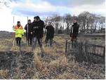
A GPS, a camera, a laptop, a digital map, a physical field, a digital setting, a physical map. Landscape architects work in a multifaceted world with mixed sources of information.
Today, it is a difficult but necessary task to combine these data sources; sometimes all of them, and sometimes only some of them. How do you combine devices, software and physical reality when needed, and the next minute recombine them for another task?
A group of PalCom researchers collaborate with landscape architects in order to find the answers.
The on-site prototype activities have two focus areas:
- to combine several devices depending on task and location. That is the SiteTracker.
- to bridge physical reality and digital representations. That is the SiteStick.
The physical and the digital world stick together
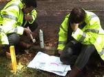
The SiteStick supports the landscape architects’ representations of ideas on site. They mark the lines of their digital designs by placing physical poles around on the site. Still, hundreds of sticks all looking alike on a big field make it challenging to figure out which poles correspond to the design of a new building.
The challenge is to combine the digital and the physical data, so to speak. The SiteStick prototype augments the poles. Each stick is fitted with an RFID tag.
With the help of a GPS and a device with a map service, such as a PDA or a tablet PC, the landscape architect will be able to see the current and intended positions of the pole.


With SiteSticks
- the user can select a group of digital poles on his PDA or tablet PC
- the ‘real world’ sticks will light up.
Tracking down a site
The SiteTracker assists landscape architects on the move. The challenge is to combine and recombine the functionality of their devices in different site-visit constellations.
Examples of landscape architects’ instruments are:
- GPS
- Laptop
- Camera
- Compass
- Mobile phone
- Maps
- Digital wirelines of the site
- e.g.
The PalCom instrument for the Landscape architects is:
- explicit formations, supporting the user’s combination and re-combination of and communication between devices, depending on task and location.
This is needed, for example, when landscape architects visit a huge site in order to find suitable viewpoints for the visual impact of a proposal. They need to locate exactly where they are and where the proposed project will be.
With the Sitetracker


- the devices used correspond and it would save landscape architects a lot of time
- A GPS provides constant information about locations,
- whilst a digital compass provides directional information about where a video camera is pointing.
- The footage from the camera is displayed on the landscape architect’s dashboard, with an overlay showing exactly where the object of interest would be positioned.
The SiteTracker prototype provides the constellations wanted by the user when needed.
This means that the combination of several devices and their data could easily be handled on-site.
Contact details
Preben Holst Mogensen
Department of Computer Science
University of Aarhus
Aabogade 34, DK- 8200 Aarhus N,
Denmark
Phone direct: +45 8942 5626
E-mail: preben(at)daimi.au.dk
Michael Christensen
Department of Computer Science
University of Aarhus
Aabogade 34, DK- 8200 Aarhus N,
Denmark
Phone direct: +45 8942 5654
E-mail: toby(at)daimi.au.dk
